Lima’s Archaeological Sites (.KMZ)
I’ve been putting together a map of some of Lima’s estimated 10,000 archaeological sites. The vast majority of these, as shown in the Lima Precolombina series, are found in the middle of regular residential areas of Lima and include Inca palaces, towering pyramids and the ruins of towns and cities.
Since posting Glorious Pre-Columbian Lima, I’ve had dozens of requests to make the Google Earth placemarks I used available as a downloadable .kmz file. This is something I definitely want to do, but with so many sites it will always be a work in progress. In the course of mapping the pre-Columbian artificial water channels the Spanish thought were rivers, for example, I noticed 3 archaeological sites I had no idea existed.
So I’ve decided to host the .kmz online so that it can be linked to in Google Earth. That way, when updates and additions are made to the map, followers will see them immediately without having to delete the old KMZ and download the new one.
Adding a “Network Link” in Google Earth is simple;
Step 1: Find a click these items on the menu
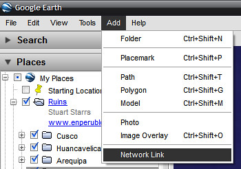
Step 2: Give the link a name (I wrote test, you should probably write “Lima ruins”) and type the KMZ address.

The actual KMZ file is found at: http://enperublog.com/maps/lima-city.kmz
This is the file that I will edit, all changes will appear in your Google Earth.
Should you download the file you will not receive updates – and if you do this, please keep a link to my blog in the description if you will pass the file on to others.
If you know something that should be included on the map, or spot something that you want me to check out, contact me here. The same goes if you want to help develop a map for other areas of Peru.
Don’t have Google Earth? Use the online version, Google Maps! (There are 2 pages, switch between them to see all sites)
Tags: Archaeology, google earth, lima, lima precolombina, ruins


