
Ancash
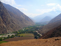
Home to some of the world’s most spectacular snow-capped mountains, and the highest in Peru, the department of Ancash consists of a narrow coastal strip and two huge cordilleras, Blanca and Negra. Between these towering mountain rages you will find the towns of Yungay, the scene of a tragedy, and Huaraz the commercial centre and capital.
Mount Huascaran at 6768m is the tallest peak in Peru and creates crystal-blue glacier-feed lagoons such as those of Llanganuco. Ancash is a word-centre in hiking, rafting, mountain climbing and biking.
Ancash was also home to the Chavin culture of 1200B.C. to 200B.C. They left as their legacy the impressive archeological complex of Chavin de Huantar, which, in 1985, UNESCO placed on the World Cultural Heritage List.
On the World Natural Heritage List is Huascaran National Park, home to wildlife species like condors, vicuñas, deer, pumas and Andean foxes.
My Blog
Lima to Huaraz
Carhuaz
Yungay Tragedy
Lagoons of Llanganuco
Caraz
Huaraz city
The Chavin culture and city
Women cooking choclo under Huascaran
Puya Raimondii
Huayhuash Codillera
Climate Change: Goodbye Huascaran
Pastoruri glacier and climb
Birdwatching in Peru
Things to do and see
Huaraz and surrounding
Asunción: Chacas
Carhuaz
Huarmey: Tuquillo beaches and Tamborero
Recuay: Pastoruri
Cordillera Huayhuash
Casma: Sechín and Tortugas
Huari: Chavín de Huantar
Huaylas: Carás
Pallasca: Cabana
Yungay: Llanganuco and Huascarán
Santa:Chimbote and Punkuri
Maps
Map of Department
Detailed highway map
Plan of Huaraz city
Back to Top ^
Huánuco
Huanuco is split between the mountainous terrain of the Huayhuash Cordillera and the forested jungle highlands of the Amazon. The capital goes by the same name, in an area with an economy based on fruit, coffee, cacao and coca production. It was in this part of Peru that the earliest evidence of human life was found, and is also home to Inca constructions.
Deeper into the jungle and downriver is Tingo Maria, home to the Tingo Maria National Park filled with dozens of rare bird, animal and plant life.
My Blog
Things to do and see
Huanuco and Surroundings
Yarowilca
Ambo
Dos de Mayo
Archeological Centers of Tantamayo
Lauricocha and the Cordillera Huayhuash
Tingo Maria
Kotosh: Temple of the Crossed Arms
Maps
Map of Department
Detailed highway map
Plan of Huanuco city
Back to Top ^
Ucayali
A vast Amazon area that used to be joined to Loreto, is home to not very many people and is being systematically and illegally destroyed by local and Brasilian loggers, this area used to be inhabited by the Panos tribe. Their mostly city-dewelling decendents live by logging and farming. The Ucayali river that runs through the department is the locals route out to the rest of the world, that and a long dirt road from the capital Pucallpa to Tingo Maria is Huanuco.
Lake Yarinacocha, one of the largest in the Amazon rainforest, is just a few minutes away from Pucallpa, and the Shipibo-Conibo people have settled along its shores. The lake is also used to rest and relaxation, tourism and water sports.
Also located in the department is the Padre Abad Boquerón Water Channel, a narrow canyon with several waterfalls.
My Blog
Things to do and see
Pucallpa and surroundings
Province of Purus
Padre Abad
Province of Atalaya
Maps
Map of Department
Detailed highway map
Plan of Pucallpa city
Back to Top ^
Lima
The city of Lima is located in the region of the same name. It was founded in 1535 and soon became the most important city in the Americas.
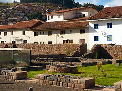
The centre of the city is on the UNESCO World Cultural Heritage List, containing examples of colonial architecture such as the many hundreds of wooden balconies, the Cathedral and various other churches.
The city is home to dozens of museums with exhibits from across the country. But if its Archeology you are after, you need not visit a museum, like the rest of the country there are ruins everywhere, suchj as the Huaca Pucllana and Huaca Huallamarca, the Pachacamac complex – the most important Pre-Inca complex on the coast. From the same civilization, spread along the Lurin valley into the Andes are dozens of cities and a part of the famous Inca Trail, eventually leading to Cusco.
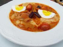
There are also beaches, water sports, modern urban districts, cuisine rated as one of the top in the world. The number of restaurants are overwhelming, you can taste that are the result of the mixing of European, African, Asian, and Andean cuisines.
Outside of the city are various destinations to visit, such as the misty desert oasis of Lachay National Reserve where the desert mountains turn green between July and November. The city of Caral, over 5000 years old and recently surpassed by another ruined city nearby to be the oldest in all of the Americas. Hotsprings of Churin, forests, rock formations and mystics of Marcahuasi, adventure sports of Luanahuaná and beautiful lakes and peaks of Nor Yauyos… there’s no end.
My Blog
Lima PreColombina: Glorious Lima before the Spanish arrival
Explorando Lima: A collection of my best Lima tourism blogs outside of the city
Poor people, Historic Buildings
Disappearance of old Miraflores
Pueblo Libre: Cruz de la Viajero
Pueblo Libre: El Bolivariano
Pueblo Libre
Museo Nacional de Arqueología, Antropología e Historia del Perú
Lima, Peru, 1944 – today. Video.
Rimac
Barrios Altos
Quinta Heeren
Barranco – Slope of the Baths
Barranco
Barrando – Iglesia de la Ermita
Tio Mario restaurant
Lunahuaná
Huaca Pucllana
Puruchuco ruins
District of San Isidro
La Costa Verde
Lima’s city walls
Central Reserve Bank of Peru
Central Market
Santiago de Surco
Parque de la Amistad
Lunch at the Cordano
Cieneguilla
Colonial Lima
Parque de las Leyendas
Huachipa
Pachacamac Ruins
Things to do and see
Lima and Surroundings
Lima, city of kings
Historic Downtown
Districs of Lima (San Isidro, Miraflores, Santiago de Surco, Barranco, Chorrillos, Pueblo Libre)
Maps
Map of Department
Detailed highway map
Plan of Lima city
Back to Top ^
Callao
Callao, once quite far from Lima is now attached to its side, once just its own city now its own department. Callao is a port, founded in 1537, it became Spain’s primary port in Peru for its primary city in the Americas, Lima. Particularly famous for its Real Felipe fortress of 1747 built to defend against pirates such as Francis Drake, there are also colonial mansions and colonial churches.
La Punta, one home to Lima’s rich, it a piece of land that projects out into the see. It’s streets and promenade are lined with homes built at the time of Peru’s independence. Across the water lay islands that are home to a variety of birds including penguins and sea leons.
Callao is also famous for its sea food, and is the birth place of many dishes such as Choritos a la Chalaca.
My Blog
Birdwatching in Peru
Things to do and see
Callao Islands
In Callao
Maps
Plan of Callao
Back to Top ^
Pasco
Pasco, half Andes, half jungle is most famous for its jungle half, where in the nineteenth century German and Austrian colonists, who brought their architecture and traditions, arrived and founded the picturesque towns of Oxapampa and Pozuzo where they still live.
The capital, Cerro de Pasco, is in mining country but the best of the area is protected in Huayllay Stone Forest National Sanctuary. In the jungle the Yanachaga-Chemillén National Park is twenty-five kilometers from Oxapampa, and it is composed of high Andean plains, pasturelands, and tropical and cloud with almost 350 species of orchids, more than 520 species of birds, and nearly 125 species of mammals such as the otter, the jaguar, the spectacled bear, the dwarf brocket deer and the giant rat, all in danger of becoming extinct.
My Blog
Things to do and see
Cerro de Pasco and Huallay
Oxapampa, Villa Rica and Pozuzo
Yanahuanca and surroundings
Maps
Map of Department
Detailed highway map
Plan of Cerro de Pasco city
Back to Top ^
Junín
Junin is characterized by its mountainous highlands to the west giving way to its Amazon region in the east. Huancayo, the modern capital, is located in one of the most fertile plains in the central Andes, allowing for an arigcultural lifestyle and economy.
As with other regions, history is abound. The area was territory of the Huancas, who fought against the Incas but were finally defeated. In La Concepción there is the Franciscan convent of Santa Rosa of Ocopa built in 1725. It holds a library with 25,000 books.
Jauja was the first Peruvian capital city, until Lima was founded shortly after due t Jauja’s lack of sea connection, and the city of Tarma on route to the jungle is known for its ideal climate.
Continueing from Tarma down the slopes of the Andes you reach Chanchamayo, San Ramón, La Merced and eventually Satipo with its river connection which leads to the Amazon.
Back in the mountains, the department is home to Peru’s second largest lake, and home to the very rare Junin Grebe bird.
My Blog
The Ashánika tribe
Pinchanaki
Velo de la Novia Waterfall
Beyoz waterfall
La Merced
Local wildlife in eastern Junin
Waterfall Tirol
Tarma
From Lima to Tarma
Huancayo
Birdwatching in Peru
Things to do and see
Huancayo and Surroundings
Chanchamayo: La Merced and San Ramón
Chupaca
Concepción: Convent of Ocopa
Jauja
Junin Reserve
Satipo
Tarma: San Pedro de Cajas and Muruhuay
Maps
Map of Department
Detailed highway map
Plan of Huancayo city
Back to Top ^
Ayacucho
Ayacucho is a large department of high Andean planes, with a ridge of jungle highlands. The most populous area is around its capital city known as both Ayacucho and Huamanga. This colonial city preserves all of its charm and if it were not for the cars, you might not know what century you were in.
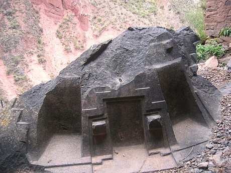
The region is full of history and is where Peru and much of Spanish South America won its independence. Further back in time, the area was home to the Waris, one of Peru’s major Pre-Inca civilizations. Their ancient capital is not far from the modern capital. Further away are Inca ruins, such as those at Vilcas Huamán.
What Ayacucho is best known for are its Easter celebrations, or Semana Santa, thousands of believers from across the world and Peru descend on the town to witness the spectacle. The region is also one of the most important centres of artisania, famous for its ceramics.
My Blog
First Impressions
History of Ayacucho
Churches of Ayacucho
Pampa de Quinua/Ayacucho – Independence
Quinua
Semana Santa: Palm Sunday
Semana Santa: Señor del Huerto
Semana Santa: Señor de la Sentencia
Semana Santa: El Encuentro
Semana Santa: Carpets of Flowers
Semana Santa: Finale
Ayacucho Market
Ayacucho to Lima by Air
María Parado de Bellido
Puca Cruz, Ayacucho
Things to do and see
Huamanga and surroundings
Huanta
Cangallo
Lucanas: Pampa Galeras and Andamarca
Parinacochas
Vilcashuamán
La Mar
Province of Paucar del Sara Sara
Huancasancos
Wari: Capital of an Ancient Empire
Maps
Map of Department
Detailed highway map
Plan of Ayacucho city
Back to Top ^
Apurimac
A small rugged department in the southern centre of the country and entry point to Cusco via the long mountainous route, with the Apurimac river and canyon separating the two. The region was deep inside Inca territory after the spread out from Cusco and conquered the Chanca. The region is full of archeological sites and wonders constructed by Peru’s most well known civilization.
The people of the region are among the poorest, and survive on an economy of agriculture in the deep valleys and hillsides of the rough terrain. Apurimac’s two main cities, Andahuaylas and Abancay are full of colonial charm.
My Blog
Things to do and see
Abancay and Surroundings
Andahuaylas and Surroundings
Chinchero Cocharcas
Aymaraes: Chalhuanca
Antabamba
Maps
Map of Department
Detailed highway map
Plan of Abancay city
Plan of Andahuaylas city
Back to Top ^
